
Bale’s geographical setting: a landscape between karst and sea
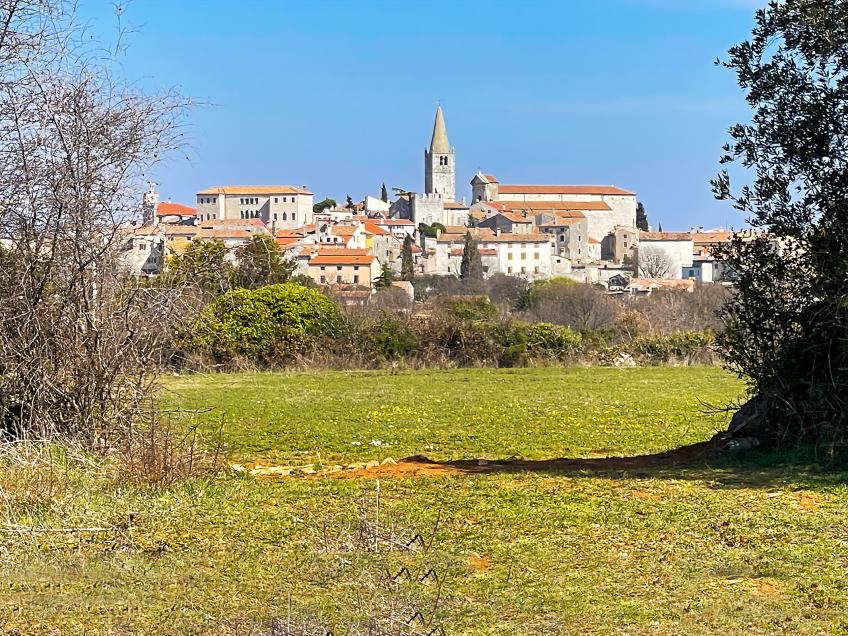
Bale stands on a rise in southwestern Istria. Its landscape links a limestone plateau, karst depressions and cultivated fields with the Adriatic coast.
Bale’s historic centre stands about 145 metres above sea level, a few kilometres inland from Istria’s western coast. The municipal centre occupies an inland site, while the municipality’s southwestern edge reaches the Adriatic. Fields, woodland and former pastures lie between its stone streets and the sea, crossed by tracks leading towards the shore. This separation explains the two distinct settings you encounter in Bale: the compact old town and the more open countryside beyond it.
The municipality comprises three settlements: Bale, Golaš and Krmed. It borders Rovinj to the northwest, Kanfanar to the north, Svetvinčenat to the east and Vodnjan to the southeast. Bale as a settlement is therefore distinct from the wider municipal territory, which includes both the coast and higher ground inland.
The D75 road passes the town on a north–south axis, with a separate branch towards Rovinj. Southward connections lead to Vodnjan and Pula, while routes further north link the area with the rest of Istria and the roads towards Trieste. Brijuni is an island destination off southwestern Istria, reached by continuing the journey by boat. The A9 motorway crosses the eastern part of the municipality, away from the old centre. This road network also explains Bale’s present role as a local centre between the larger towns and the coast.
Low hills and enclosed depressions
The Bale area forms part of the gently undulating carbonate plateau of western and southern Istria. Here, a plateau means an extensive, largely levelled surface within which low rounded hills alternate with hollows. Across the wider municipality, the ground rises from the coastal belt to about 200 metres. Gentle slopes predominate, but low elevation does not make the terrain flat or uniform.
Around Bale and towards the municipality’s northeastern edge are numerous dolines: enclosed karst depressions without the usual surface river outlet. Soil and rainwater can accumulate within them. Rock may be exposed on an adjacent rise while deeper soil covers the bottom of a hollow. Even over short distances, this creates different conditions for cultivation, tree growth and moisture retention.
Limestone formed in an ancient shallow sea
Much of the bedrock around Bale consists of limestone from the Cretaceous, a period of the Mesozoic Era. Lower Cretaceous deposits extend west of the town and through the Golaš area. They formed within the former Adriatic Carbonate Platform, a broad shallow-marine setting where carbonate material, including the remains of marine organisms, accumulated. Over geological time, those sediments became rock.
The sea did not cover the same ground without interruption. Deposition alternated with emergence, weathering and the development of land surfaces. Later deformation, uplift and prolonged dissolution of carbonate rocks helped shape today’s relief. A layer’s present position on land or beneath the sea therefore does not, by itself, reveal the environment in which it formed.
A local example lies beneath the sea at Kolone, where sauropod dinosaur bones were found in Lower Cretaceous limestone. The geological succession there includes shallow-marine, intertidal and lake deposits. The seabed where the fossils were discovered is the site’s present setting, whereas the dinosaurs were land animals. These fossils add evidence of changes in ancient shorelines and land areas.
Adria and present-day tectonic movement
Istria belongs to the Adriatic microplate, also called Adria. This is part of Earth’s lithosphere, its rigid outer shell, whose movement scientists study using methods including GPS measurements. The carbonate platform in which limestone accumulated and the tectonic microplate are different concepts: one describes a depositional setting, the other a large moving body of rock.
Adria lies within the broader zone of interaction between Africa and Eurasia. Geodetic measurements support its movement and rotation relative to stable Eurasia, with deformation around the edges of the Adriatic region. The Alps and Dinarides are important parts of this regional tectonic setting. Movement involves the rotation of crustal blocks and changes along faults, while scientists investigate the microplate’s boundaries and their development through different models.
Southwestern Istria lies closer to Adria’s comparatively rigid interior than to its active marginal belts. This helps explain its quieter tectonic setting, but provides no guarantee that strong earthquake shaking cannot be felt in Bale or Pula. Seismic hazard also includes sources beyond the immediate surroundings. Shaking at an individual site depends on the distance and depth of the earthquake source and on local ground conditions. Effects on buildings also depend on how they were constructed. The timing of a future earthquake cannot be predicted precisely.
Red soil and water in karst terrain
Terra rossa, the characteristic red soil of Istria, does not form a uniform blanket around Bale. It alternates with brown soils on limestone, exposed rock and deeper deposits in hollows. Iron minerals, particularly hematite, give it its red colour. Alongside weathering of the carbonate bedrock, material brought from elsewhere, such as windblown dust, can contribute to its formation.
For plants, soil depth matters as well as composition. A shallow pocket of earth between rocks and deep soil at the bottom of a doline offer different stores of water accessible to roots. Summer drought therefore affects sites differently. Long cultivation has further altered that natural pattern: people removed stones, shaped plots and worked places where enough soil had accumulated.
In karst, much water infiltrates through fractures into the subsurface. The lack of large permanent surface streams does not mean there is no water underground. After heavy rainfall, water can also collect in low hollows, especially where surface drainage is restricted. Dry ground and temporarily flooded fields can coexist in the same karst landscape.
In Bale’s farming countryside, ponds and open channels formed a system for collecting and directing rainwater. Ponds also supplied livestock with water and now remain important small aquatic habitats. Filling a pond or interrupting a channel changes the path water takes through a field. Preserving them therefore serves hydrological and ecological functions as well as conserving local history.
The sea moderates the climate, relief creates local differences
The northern Adriatic influences temperatures and air circulation around Bale. The sea warms and cools more slowly than the land, moderating coastal temperature extremes. Summers are warm and winters milder than in higher inland areas. The warmer part of the year nevertheless includes droughts, heatwaves and thunderstorms, while the bora and jugo winds can substantially change conditions by the sea.
Within this regional setting, conditions differ between the coast, exposed hills and sheltered hollows. On calm cold nights, local relief strongly affects temperature, and north-facing and south-facing slopes receive different amounts of solar energy. A single annual average therefore cannot describe all conditions within the municipality. The position of a plot, wind and available water also matter in understanding vegetation and farming.
A landscape also shaped by its inhabitants
Olive groves, vineyards and grasslands alternate with scrub and woodland around Bale. This mosaic reflects natural conditions and changes in how residents worked the land. Some present-day scrub and woodland developed on abandoned fields and pastures after cultivation or grazing ceased. Vegetation cover does not necessarily represent woodland that has remained unchanged since ancient times.
Evergreen holm oak and deciduous downy oak occur among other species adapted to different sites. Differences in soil, exposure and past land use help explain why an open meadow, dense scrub and a small wood can be immediate neighbours. Towards Bale’s coast, this terrestrial mosaic extends to coves and the rocky edge of the sea.